🛒 Buy 2 Maps, Get 3rd Map Free!
📦 Free Shipping On All Orders
🚚💨 Fast Delivery From The USA!
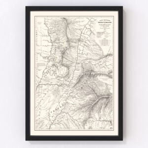
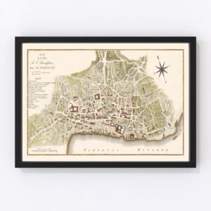
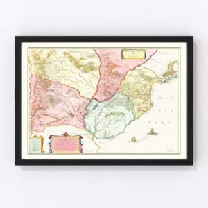
Old Maps of Paraguay
Take a look through our collection of Old Maps of Paraguay.
Paraguay, a landlocked country, is located within South America. It is bordered by Argentina, Brazil, and Bolivia. There are ports located on both the Paraguay and Paraná rivers that exit through to the Atlantic Ocean. Paraguay is home to a population of over 7 million inhabitants, 3 million of which reside in the capital, and largest, city of Asunción. The total land area of the country is 406,796 square kilometers, or 157,065 square miles, making Paraguay the 59th largest country in the world. The government system is a representative democratic republic. The current president is Mario Abdo Benítez.
The Río Paraguay river splits Paraguay into two geographical regions – the eastern region of Región Oriental and the western region of Región Occidental, which is a part of the Gran Chaco. The terrain of Paraguay mainly consists of grassy plains and hills. The highest peak in Paraguay is located within southeastern Paraguay, and it is Mount San Rafael, standing at an altitude of 2,789 feet or 850 meters. Although the country is landlocked, there are a few beach areas surrounding lakes. The climate of the country is noted to be tropical or subtropical, with wet and dry periods. The absence of mountain ranges in the country causes high winds, sometimes as high as 161 km/h, or 100 mph.Common wildlife animals include marsh deer, monkeys, armadillos, anteaters, otters, wild boars, jaguars, bats, and tapirs. Birdlife is also very vast in Paraguay, and common bird species include parakeets, eagles, rheas, toucans, herons, and ibises. Within Paraguay, there are several endangered species which are due to illegal trades and activity. For example, parrots and macaws are threatened from it, while snake, armadillo, and iguana skins are all used for exports, killing those species in the process. To help preserve the environment, 300,00 hectares of land has been turned into a reservation within northern Paraguay.
The largest exports Paraguay produces are soybeans, electricity, corn, frozen bovine meat, bovine meat, soybean oil, as well as soybean meal. Agriculture is the largest sector within the economy. Paraguay is the sixth largest soybean producer in the world, the second largest producer of stevia, and the ninth largest exporter of beef. In 2018, Paraguay was able to solidify itself as the world’s largest producer of both maize and sugarcane. The mineral industry accounts for 25% of the country’s total GDP, and it also employs 31% of the country’s workforce.
The population of Paraguay is dispersed and distributed unevenly all across the country. In fact, Paraguay has one of the lowest population densities in the world, with 18 people per square kilometer, or 45 people per square mile. The Gran Chaco region of Paraguay, which is about 60% of all the country’s land, only populated 2% of the country’s population. Paraguay is home to one of the most homogenous populations within any South American country, as 95% of the people identify as Mestizo, or mixed white and indigenous. Emigration rates have continued to rise since the mid 20th century, which is due to employment purposes.