🛒 Buy 2 Maps, Get 3rd Map Free!
📦 Free Shipping On All Orders
🚚💨 Fast Delivery From The USA!
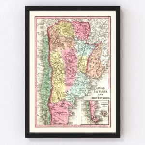
Old Maps of Uruguay
Browse through our collection of Old Maps of Uruguay.
Uruguay is a country located in South America, sharing its borders with both Argentina and Brazil. The country spans an area of 181,034 square kilometers, or 69,898 square miles. With a total population of 3.51 million inhabitants, 2 million of these people reside in the capital, and largest city of Uruguay, Montevideo. The country is known to be one of the most developed within Latin America. In fact, Uruguay is ranked at number one within Latin America in democracy, peace, low corruption, and e-government. The country also ranks high on measures of personal rights, tolerance, and inclusion issues.
The landscape of Uruguay is mainly rolling plains with low hill ranges as well as a fertile coastal lowland. There are four major basins within the country, and they are the Río de la Plata Basin, the Uruguay river, the Laguna Merín, and the Río Negro. The largest internal river within the country is also the Río Negro, with a length of 466 miles. Cerro Catedral is the highest point within the country, with an altitude of 514 meters, or 1,686 feet. The capital city of Montevideo is the southernmost capital city within the Americas, and is the third most southern capital city in the world.
The climate of Uruguay is relatively mild and fairly uniform, which is likely because of its location inside a temperate zone. High humidity and fog is fairly common all throughout the country due to its lack of natural water. Because of a lack of mountains, high winds and rapid changes with weather fronts are also very common. The average annual precipitation is greater than 40 inches, or 1,000 mm. Any form of precipitation is evenly distributed across the entire country.
Economically, the largest exports within Uruguay are frozen bovine meat, bovine meat, concentrated milk, sulfate chemical woodchip, soybeans, rice, and malt. The tourism industry serves as a key sector within the Uruguay economy. In 2012, it was estimated that there were 97,000 jobs within the tourism sector and accounted for 9% of the GDP. In 2013, 2.8 million tourists would enter Uruguay. Agriculture serves another key role in the economy of Uruguay, as the country is amongst the world’s top producers of soybeans, greasy wool, horse meat, beeswax, as well as quinces.
A great majority of the Uruguayan population have European descent, with 87.7% of the population being ethnically white. The population growth rate of Uruguay is much lower than other Latin American countries. This is because of a population starting to develop and age, as well as a slowing birth rate. The median age of Uruguay is 35.3 years old, which is higher than the global average. This is because of a low birth rate, a high life expectancy, as well as high levels of emigration amongst younger people. The largest city within Uruguay is Montevideo, with a population of around 1.9 million people. The remainder of the population resides in 30 different towns.