🛒 Buy 2 Maps, Get 3rd Map Free!
📦 Free Shipping On All Orders
🚚💨 Fast Delivery From The USA!
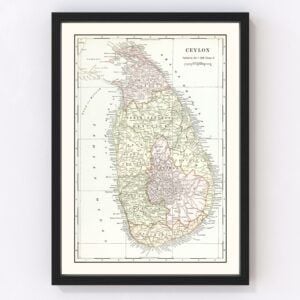
Old Maps of Sri Lanka
Browse through our collection of Old Maps of Sri Lanka.
Sri Lanka is an island country that is located in South Asia and lies within the Indian Ocean. The capital city is Sri Jayawardenepura Kotte, or Kotte. The largest city is Colombo, which also serves as the country’s financial center as well. With a population well over 22 million, Sri Lanka is considered a multinational state due to the abundance of diverse cultures, languages, and ethnicities. The total land area of Sri Lanka is 65,610 square kilometers, or 25,330 square miles, which makes the country the 120th largest in the world, and the 25th largest island in the world.
The topography of the country consists of flat and rolling plains. The highest point within the country is Pidurutalagala, which reaches around 2,524 meters, or 8,281 feet above sea level. There are 103 rivers located within Sri Lanka. The longest of these is Mahaweli River, which reaches well over 305 kilometers, or 208 miles long. The island is rich in minerals, such as ilmenite, feldspar, graphite, and silica. Petroleum and natural gasses have been discovered on the island, and the extraction of these resources has since started.Sri Lanka is home to the highest biodiversity per unit in any Asian country. 22% of all mammals found on the island are endemic, while 27% of all species of flowering plants are endemic. There are four ecoregions located within Sri Lanka which is what causes such high biodiversity. Currently, 61 wildlife reserves, 22 national parks, and four nature reserves are in the country to protect the environment. 26.5% of Sri Lanka’s is legally protected, which is a higher number than most Asian countries. In 1956, 44.2% of the country was covered in forest. As of 2010, the country’s forest cover was 28.7%. The reason behind such rapid deforestation is for economic purposes.
The economy of Sri Lanka has a history of being a plantation economy, due to its amount of natural resources and agricultural products the country would export. Currently, rubber, cinnamon, and Ceylon tea remain as trademark exports. Industrialization within the country has created more of an economical focus on textiles, food processing, and finance. The largest sectors within Sri Lanka are tourism, tea export, clothing, rice production, as well as other agricultural products. As of 2020, the service sector makes up 59.7% of the GDP, industrial sector with 26.2%, and the agricultural sector with 8.4%. Tourism played a large role in the economy of Sri Lanka, but has since crashed due to Covid-19.
The population of Sri Lanka is still young, with over a fourth of the population aged 15 years or younger, while nearly half of the population is under 30 years old. The life expectancy within the country is around 81 years old for women and 74 years for men. The annual growth rate of Sri Lanka is 0.5%, with a birth rate of 13.8 births per 1,000 people and a death rate of 6.0 deaths per 1,000 people.