🛒 Buy 2 Maps, Get 3rd Map Free!
📦 Free Shipping On All Orders
🚚💨 Fast Delivery From The USA!
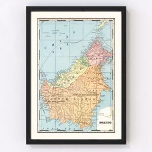
Old Maps of Borneo
Explore our collection of Old Maps of Borneo.
Borneo is the third largest island in the world and is located in the center of Maritime Southeast Asia. Because of its size and isolation, the country is politically divided amongst three nearby countries, which are Malaysia, Brunei, and Indonesia. Indonesia owns around 73% of the island. The island holds a total population of around 23 million inhabitants. Surrounding the island of Borneo are two mountain ranges. The Ligesing Range is one of them, and splits the island of Borneo into two. It runs from West Kalimantan and to south of Sarawak. The other range is the Main Range, which runs from the east and the west and is nearly the length of the entire island of Borneo.
When it comes to the economy of Borneo, agriculture, logging and mining, oil and gas, and ecotourism are the main sectors. The country is poor in natural resources, as the gold, diamonds, mercury, gypsum, and iron within the country has previously been exploited with an individual producer basis. However, Borneo, more specifically Brunei, is a very oil-rich country, causing the country to become one of the largest oil producers within Southeast Asia.Did you know that Borneo is home to one of the oldest rainforests in the world? The Borneo rainforest is estimated to be around 140 million years old. The rainforest's great size makes it a perfect place for many endemic species to thrive, such as the endangered Bornean orangutan. The many rainforests located all across Borneo are also home to Rafflesia arnoldii, otherwise known as the monster flower, the largest flower in the world. With such large rainforests does come some conservation issues, mainly with the Indonesian and Malaysian wood industry. Half of the annual tropical timber acquisition originates from Borneo. Along with this, palm oil plantations have been edging closer and closer to primary rainforest land.
Our modern day knowledge regarding Borneo dates back to travelers through Southeast Asia in the 14th century, with the first recorded visitor being Odoric of Pordenone around 1330. Around the 1880s, the country of Brunei became a British protectorate. Brunei would not gain back its independence until January 1st, 1984. Since Borneo is not a country, but rather an island split between three countries, there is no official leader of Borneo.
And lastly, some fun facts about Borneo:
Borneo is one of the two only places on Earth one could see an orangutan in the wild. The other place is Sumatra, an island in Indonesia
Borneo is home to the tallest mountain in Southeast Asia, which is Mount Kinabalu. Mount Kinabalu is also the third-highest peak in the world with an elevation of 13,435 feet.
Borneo is so biodiverse, that in the past decade, there have been 360 new species found on the Island.
Out of the 222 mammals one can find on Borneo, 44 of them can only be found exclusively in Borneo.
Borneo is home to the Bornean pygmy elephant and the Bornean sun bear, which are both the smallest elephant and bear species found in the world.